
 Event Briefing - Excess Rainfall - Covered Area Rainfall Event - Trinidad and Tobago - October 2, 2019
 |
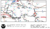
Karen was the twelfth tropical cyclone in the 2019 Atlantic Hurricane Season. On 22 September it developed as a tropical storm to the northeast of Trinidad and Tobago. On the same day, it passed over the waters between Grenada and Saint Vincent and the Grenadines at a distance of approximately 45 km from both countries. These islands were affected by tropical-storm-force winds. On the following day, Karen left the Windward Islands moving towards the northwest across the southeastern Caribbean Sea. |
 Event Briefing - Wind and Storm Surge - Windward Islands - September 24, 2019
 |
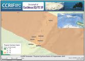
Karen was the twelfth tropical cyclone in the 2019 Atlantic Hurricane Season. On 22 September it developed as a tropical storm to the northeast of Trinidad and Tobago. On the same day, it passed over the waters between Grenada and Saint Vincent and the Grenadines at a distance of approximately 45 km from both countries. |
 Event Briefing - Wind and Storm Surge - British Virgin Islands - September 27, 2019
 |
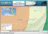
Karen was the twelfth tropical cyclone in the 2019 Atlantic Hurricane Season. On 22 September it developed as a tropical storm to the northeast of Trinidad and Tobago. On the same day, it passed over the waters between Grenada and Saint Vincent and the Grenadines, heading for the southeastern Caribbean Sea. On 24 September, Tropical Storm Karen approached Puerto Rico and the US and British Virgin Islands. |
 Event Briefing - Wind and Storm Surge - The Bahamas and the Turks and Caicos Islands - September 17, 2019
 |
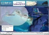
Humberto was the ninth tropical cyclone in the 2019 Atlantic Hurricane Season. On 12 September it developed as a tropical depression over Bahamas Central1 at a distance of |
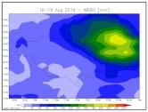 Event Briefing - Excess Rainfall - Covered Area Rainfall Event - Jamaica - August 16-18, 2019
 |
A tropical wave produced periods of rain/showers and thunderstorm activity over north-eastern Jamaica on 16 August 2019. This event briefing describes the impact of the precipitation on the island of Jamaica over the period 16-18 August 2019. The Rainfall Index Loss (RIL) calculated for this Covered Area Rainfall Event (CARE), which occurred in Jamaica, starting on 16 August and ending on 18 August 2019 was below the attachment point of Jamaica’s Excess Rainfall policy and therefore no payout is due. |
 Event Briefing - Earthquake - Nicaragua - July 31, 2019
 |
A magnitude 5.9 earthquake occurred at 05:54:55 UTC on 31 July 2019 (30 July 2019 at 23:54:55 local time), 24.6 km (15.3 mi) N of La Libertad, El Salvador; 45.9 km (28.5 mi) N of Santa Tecla, El Salvador and 46.6 km (28.9 mi) NNE of San Marcos, El Salvador. Initial estimates from the United States Geological Survey (USGS) located the epicentre of the event (Figure 1) at 13.266°N, 89.338°W, and at a depth of 72.5 km (45 mi). Nicaragua was the only CCRIF member country where peak ground acceleration, computed with the SPHERA model, was greater than 0.01g for this earthquake. |
 Event Briefing - Earthquake - Nicaragua - July 8, 2019
 |
A magnitude 5.2 earthquake occurred at 00:09:02 UTC on 8 July 2019 (7 July 2019 18:09:02 local time), 25.4 km (15.8 mi) N of La Cruz, Costa Rica; 31.4 km (19.5 mi) SE of Liberia, Costa Rica and 69 km (42.9 mi) NNW of Rivas, Nicaragua. Final estimates from the United States Geological Survey (USGS) located the epicentre of the event (Figure 1) at 10.844°N, 85.632°W, and at a depth of 60.7 km (37.7 mi). Nicaragua was the only CCRIF member country where peak ground acceleration, computed with the SPHERA model, was greater than 0.01g for this earthquake. |
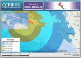
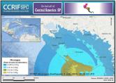
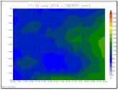 Event Briefing - Excess Rainfall - Covered Area Rainfall Event - Trinidad - June 17-19, 2019
 |
A tropical wave and an active Inter-Tropical Convergence Zone (ITCZ) produced prolonged periods of rain/showers and thunderstorm activity over Trinidad and Tobago between 17 and 19 June 2019, generating adverse weather in Trinidad. This event briefing describes the impact on the island of Trinidad of the heavy precipitation received during this period. The Rainfall Index Loss (RIL) calculated for this Covered Area Rainfall Event (CARE), which occurred in Trinidad, starting on 17 June and ending on 19 June 2019. |
 Event Briefing - Excess Rainfall - Covered Area Rainfall Event - Nicaragua - May 19-31, 2019
 |
During the second half of May, a persistent area of low pressure located over the eastern Pacific Ocean created conditions favourable for the development of thunderstorms and showers over Central America and the surrounding waters1 2. In particular, the Nicaraguan territory was affected by high thunderstorm activity and associated heavy precipitation. |
 Event Briefing - Earthquake - Nicaragua - May 16, 2019
 |
A magnitude 5.9 earthquake occurred at 16:22:16 UTC on 16 May 2019 (10:22:16 local time), 45.9 km (28.5 mi) ENE of Jiquilillo, Nicaragua; 78.7 km (48.9 mi) E of Chinandega, Nicaragua and 75 km (46.6 mi) E of El Viejo, Nicaragua. Estimates from the United States Geological Survey (USGS) located the epicentre of the event (Figure 1) at 12.624°N, 87.856°W, and at a depth of 62.0 km (38.5 mi). Nicaragua was the only CCRIF member country where peak ground acceleration, computed with the MPRES model, was greater than 0.01g for this earthquake. |