
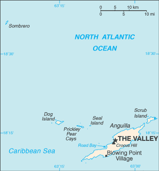
Anguilla (pronounced /æŋˈɡwɪlə/ ang-GWIL-a, like Va-NIL-a) is a British Overseas Territory in the Caribbean, one of the most northerly of the Leeward Islands in the Lesser Antilles. It consists of the main island of Anguilla itself, approximately 26 km (16 mi) long by 5 km (3.1 mi) wide at its widest point, together with a number of much smaller islands and cays with no permanent population. The island's Capital is The Valley. The total land area of the territory is 91 km2 (35 sq mi),[2] with a population of approximately 13,500 (2006 estimate). |
 Official Name: Anguilla Official Name: Anguilla
Capital: The Valley Population: 14,436 (July 2009 est.) Area: 91 Sq Km Coastline: 61 km Population density: 130 Inhab/sq Km (July 2005) Religion: Anglican 29%, Methodist 23.9%, other Protestant 30.2%, Roman Catholic 5.7%, other Christian 1.7%, other 5.2%, none or unspecified 4.3% (2001 census) Language: English Ethnic group: black (predominant) 90.1%, mixed, mulatto 4.6%, white 3.7%, other 1.5% (2001 census) Government: Overseas territory of the UK Currency: East Caribbean dollar |
 |
|
Inglés