
 Event Briefing - Earthquake - Nicaragua - July 27 2018
 |
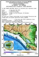
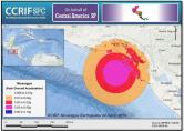
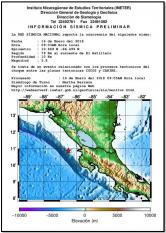
A magnitude 5.3 earthquake occurred at 20:42:03 UTC on 27 July 2018, (14:42:03 local time), at 64.6 km (40.1 mi) SSW of Intipucá, El Salvador; 83.3 km (51.8 mi) SSE of Puerto El Triunfo, El Salvador and 85.5 km (53.1 mi) SSE of Usulután, El Salvador. |
 Event Briefing - Tropical Cyclone Beryl - Wind and Storm Surge - DMA-MSR-HTI - July 20, 2018
 |
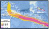
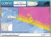
Beryl was the first tropical cyclone that reached the hurricane category in the 2018 Atlantic Hurricane Season. It formed as a tropical depression in the Atlantic Ocean on 5 July 2018 at 1500UTC and it became a tropical storm on 5 July at 1830UTC. It reached a hurricane category 1 on 6 July at 0900UTC and kept this intensity until 7 July at 1500UTC, when it was downgraded to a tropical storm. Just before making landfall on the Leeward Islands, the system became an open trough. |
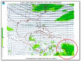
 Event Briefing - Tropical Cyclone Beryl - Wind and Storm Surge - DMA-MSR - July 10, 2018
 |
Beryl was the first tropical cyclone that reached the hurricane category in the 2018 Atlantic Hurricane Season. It formed as a tropical depression in the Atlantic Ocean on 5 July 2018 at 1500UTC and it became a tropical storm on 5 July at 1830UTC. It reached a hurricane category 1 on 6 July at 0900UTC and kept this intensity until 7 July at 1500UTC, when it was downgraded to a tropical storm. Just before making landfall on the Leeward Islands, the system became an open trough. |
 Event Briefing - Earthquake - Nicaragua - May 6 2018
 |
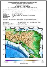
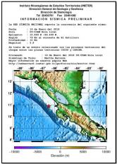
A magnitude 5.2 earthquake occurred at 12:37:58 UTC on 6 May 2018, (06:37:58 local time), at 4.6 km (2.8 mi) ENE of Intipucá, El Salvador; 23.3 km (14.5 mi) SW of La Unión, El Salvador and 35.5 km (22.1 mi) SSE of San Miguel, El Salvador. |
 Event Briefing - Earthquake - Nicaragua - April 24 2018
 |
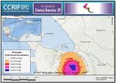
A magnitude 5.6 earthquake occurred at 02:29:53 UTC on 24 April 2018, (20:29:53 on 23 April, local time and date), 41.1 km (25.6 mi) SW of Jiquilillo, Nicaragua; 68.7 km (42.7 mi) W of Chinandega, Nicaragua and 65.6 km (40.8 mi) WSW of El Viejo, Nicaragua. |
 Event Briefing - Earthquake - Nicaragua - January 16 2018
 |
A magnitude 5.8 earthquake occurred at 15:03:54 UTC on 16 January 2018, (09:03:54 local time), 61.2 km (38.0 mi) SW of San Juan del Sur, Nicaragua; 77.9 km (48.4 mi) SW of Rivas, Nicaragua and 100.7 km (62.6 mi) S of San Rafael del Sur, Nicaragua. |
 Final Event Briefing - Earthquake - Nicaragua - January 16 2018
 |
A magnitude 5.9 earthquake occurred at 15:03:54 UTC on 16 January 2018 (09:03:54 local time), 62.6 km (38.9 mi) SW of San Juan del Sur, Nicaragua; 79.3 km (49.3 mi) SW of Rivas, Nicaragua and 101.3 km (62.9 mi) S of San Rafael del Sur, Nicaragua. |
 Event Briefing - Earthquake - Nicaragua - January 11 2018
 |
A magnitude 5.0 earthquake occurred at 17:03:19 UTC on 11 January 2018 (11:03:19 local time), 22.4 km (13.9 mi) NNE of Tilarán, Costa Rica; 44.7 km (27.8 mi) SE of San José, Costa Rica and 53.9 km (33.5 mi) S of San Carlos, Nicaragua. |
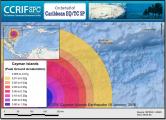 Event Briefing - Earthquake - Cayman Islands - January 10 2018
 |
A magnitude 7.6 earthquake occurred at 02:51:31 UTC on 10 January 2018, (21:51:31 on 9 January, local time and date), 201.9 km (125.5 mi) NNE of Barra Patuca, Honduras; 303.1 km (188.3 mi) SW of George Town, Cayman Islands and 305.7 km (190.0 mi) SW of West Bay, Cayman Islands. |
 Event Briefing - Excess Rainfall - Covered Area Rainfall Event - Trinidad - December 30-31, 2017
 |
A low-level system with prolonged and heavy rainfall affected CCRIF member country, Trinidad and Tobago. Trinidad and Tobago has two Excess Rainfall policies – one for the island of Trinidad and the other for the island of Tobago. |