
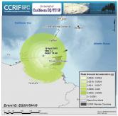
 Event Briefing - Trinidad and Tobago Earthquake - April 16, 2015
 |
A magnitude 5.2 earthquake occurred at 02:24:16 UTC (21:24:16 local time) on 16 April 2015 north west of Trinidad and Tobago. Initial estimates from the United States Geological Survey (USGS) locate the epicentre of the event at 10.859ºN, 62.459ºW, and at a depth of 76.5 km. |
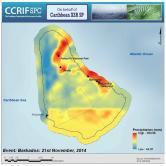 Event Briefing - Excess Rainfall - Trough System - November 21 - 22 2014
 |
Interaction of the Tropical Upper Tropospheric Trough (TUTT) and the Inter-Tropical Convergence Zone (ITCZ) led to enhanced atmospheric instability and produced moderate to heavy showers with isolated embedded thunderstorms in the Eastern Caribbean on 21 and 22 November 2014. |
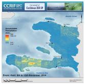 Event Briefing - Excess Rainfall - Trough System - November 8 - 12 2014
 |
A low pressure trough moving through the Western Atlantic brought continued rainfall to Haiti from 9 to 11 November 2014. The trough had affected Anguilla and St. Kitts and Nevis a few days earlier1, making Haiti the third CCRIF member country with an Excess Rainfall policy2 to be affected by the system. |
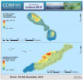 Event Briefing - Excess Rainfall - Trough System
 |
A low pressure trough, located over the northern Lesser Antilles brought heavy showers and thunderstorms to much of the British and US Virgin Islands and the Lesser Antilles from 7 to 8 November 2014. |
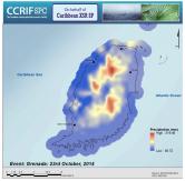 Event Briefing - Excess Rainfall - Covered Area Rainfall Event - Grenada
 |
On 23 October 2014, Grenada experienced heavy rainfall as a result of a very strong easterly tropical wave that affected the southeastern Windward Islands of the Lesser Antilles. This triggered a Covered Area Rainfall Event (CARE) according to CCRIF’s Caribbean Rainfall Model. |
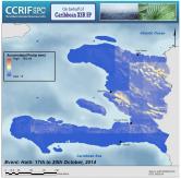 Event Briefing - Excess Rainfall - Covered Area Rainfall Event - Haiti
 |
On 17 October 2014, strong heating caused convection over the higher terrain of Haiti and, combined with a frontal system from Cuba and The Bahamas, created intense precipitation over the country. Haiti experienced torrential rainfall on 17 to 18 October 2014, which triggered a Covered Area Rainfall Event (CARE) according to CCRIF’s Caribbean Rainfall Model. |
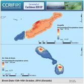 Event Briefing - Excess Rainfall - Tropical Cyclone Gonzalo
 |
Tropical Cyclone (TC) Gonzalo affected four CCRIF member countries: Anguilla, Antigua and Barbuda, Bermuda and St. Kitts and Nevis. Of these countries, only Anguilla and St. Kitts and Nevis have Excess Rainfall (XSR) policies. As a result, this briefing describes the reported losses and damage in Anguilla and St. Kitts and Nevis due to extreme rainfall as a result of the passage of TC Gonzalo. |
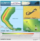 Event Briefing - Tropical Cyclone Gonzalo
 |
On 12 October 2014 at 1:30 pm AST (1730 UTC), the National Hurricane Center (NHC) produced a weather outlook on the development of Tropical Storm Gonzalo east of the northern Leeward Islands. Tropical storm warnings were issued for a number of Caribbean islands including CCRIF member countries Antigua and Barbuda, Anguilla, and St. Kitts and Nevis. |
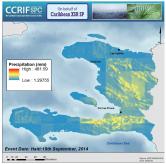 Event Briefing - Haiti Excess Rainfall
 |
Haiti experienced torrential rainfall on 19 and 20 September 2014 and again on 23 and 24 September 2014. This period of rainfall produced two Covered Area Rainfall Events (CAREs) on 19 and 23 September respectively. |
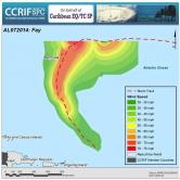 Event Briefing - Tropical Cyclone Fay
 |
On 10 October 2014, the National Hurricane Center (NHC) produced a weather outlook on the development of a subtropical depression to the south of Bermuda. A tropical storm watch was issued for Bermuda at 1500 UTC. By 2100 UTC on the same day, the depression had strengthened to Subtropical Storm Fay located about 525 miles (845 km) south of Bermuda. |